

Website designed and maintained by KOR Communications
© Lower Otter Restoration Project


Queen’s Green Canopy

The Environment Agency, on behalf of the Lower Otter Restoration Project, has been granted a virtual plaque after planting 225 trees to form part of the Queen’s Green Canopy which marked the 2022 Platinum Jubilee.

Sign up for news from conservation trust
2 January 2024: After a fascinating journey over the past few years, we are pleased to be able to say that the construction phase of the pioneering Lower Otter Restoration Project is now complete.
As a result, this website will no longer be updated, but it is our intention that it should remain available online as a publicly available source of information until the end of 2024.
To comply with data protection legislation, the project mailing list is being deleted as no fresh updates will be issued by this route.
The Lower Otter is now being managed by the Pebblebed Heaths Conservation Trust and you can sign up for their newsletters here.
You can still email the project team and your message will be passed to the most relevant team member for a response.
On behalf of the whole team we would like to thank all those partners and members of the public who have supported us in this challenging and important project which has led to the creation of 55ha of fantastic intertidal habitat, benefiting wildlife and the community.
Residents celebrate opening of the 'Elizabeth Bridge'
24 November 2023: The brand new 70m "Elizabeth Bridge" has been officially opened by Hon. Charles Fane Trefusis and Mark Rice, Environment Agency Area Director, marking a significant milestone for the project.
Click here to read more.

Latest updates

Q&A
Answers to the most frequently asked questions about the project are available here.


Environment

Environmental Statement
To see the Lower Otter Restoration Project Environmental Statement, click here.


Planning application -
The Lower Otter Restoration Project (LORP) is restoring the Otter estuary, reconnecting it with its floodplain and creating approximately 55 hectares of mudflat and saltmarsh, and providing a better place for people and wildlife.
The original motivation for LORP arose from a desire by the landowner, Clinton Devon Estates (the Estate), to manage the lower Otter valley as sustainably as possible in the face of a rapidly changing climate. The Environment Agency’s involvement in the project arose from a statutory need to provide compensatory habitat for habitat losses in the Exe Estuary. The desire of these project partners is to improve the natural functioning, ecological health and environmental status of the river, demonstrate climate change adaptation and reduce risk to wildlife and public infrastructure under future climate change.
The natural environment of the Otter estuary has, for hundreds of years, been modified by humans. These changes have led to a disruption of natural processes with the river no longer able to adapt and move naturally across the floodplain as it once did, nor can it cope effectively with flooding events, which are more prevalent due to climate change. There is a strong argument to take action.

Risks if no action had been taken
Continued flooding to public highway to South Farm
Continued flooding of Budleigh Salterton Cricket Club
Catastrophic breaching of embankments with potential for lack of funding to make repairs
Loss of public footpath access
Erosion of old municipal tip.

Opportunities
Secured and improved public access
Secured public amenities
Enhanced natural wildlife habitats
Restored natural processes
Restoration of 55 hectares of wetland habitat
Creation of compensatory habitat for habitat losses in the Exe Estuary
Otter estuary allowed to respond and adapt naturally to climate change
Enhancement of the area for environmental tourism
Funding available
Clinton Devon Estates has been working in partnership with the Environment Agency throughout LORP’s appraisal and design process. The project vision is:
A healthy, sustainable Otter estuary and river, well connected to its floodplain, with active natural processes and a range of typical habitats and species. Flood risk is understood and managed in a coordinated way. Access to a network of footpaths and trails is maintained and improved where appropriate. Local landowners and communities are engaged in and supportive of management.


The objectives for LORP are:
Deliver more sustainable management in the face of climate change;
Improve natural functioning of the Otter estuary; Improve the quality of habitats and wildlife;
Provide a minimum of 14.5ha of compensatory intertidal habitat;
Safeguard public access;
Reduce risk of contamination from the old municipal tip;
No increase in flood risk to property; and
No impact on groundwater abstractions for drinking water.

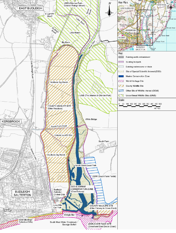
LORP is located within the floodplain of the Otter estuary, within the River Otter valley in Devon. The site lies directly south west of Otterton, directly east of Budleigh Salterton and approximately 6km east of the Exe Estuary.
The entire site lies within the East Devon Area of Outstanding Natural Beauty. Located along the coast at the mouth of the estuary is the Dorset and East Devon Coast World Heritage Site and the Otter Estuary Site of Special Scientific Interest extends from this point to the tidal limit. The estuary and marshes support a wide variety of breeding and wintering bird species, including waders and wildfowl, and form part of a network of important feeding sites which includes the Axe Estuary (to the east) and the Exe Estuary (to the west).
Footpaths have been designated along all of the embankments, and at the western edge of the floodplain. All are popular, with the most well-
Manmade changes to the river and estuary mean that, after heavy rainfall, flood waters cannot flow down the river channel to the estuary. Large fluvial floods overtop the embankments every few years, leading to flooding of the wider floodplain. This flooding can last for several days, because the culverts that drain the area are small and are restricted by the tide. In this situation both South Farm Road and Budleigh Salterton Cricket Club are under water.
The pavilion for Budleigh Salterton Cricket Club has been known to flood up to its eaves. Footpaths are currently threatened and frequently damaged by flooding, a situation expected to get worse over time due to climate change. Water can also flow over the disused refuse tip. It is also possible for very high tides to overtop the embankments, although this is less common.
As our climate changes, with both rising sea levels and increased strength and frequency of storms, the aging embankments are becoming ever more vulnerable to breaching. In September 2018 a breach was narrowly averted, and the South West Coast Path was diverted for six months whilst a repair was implemented.
If the embankments fail, parts of the natural floodplain will be regularly inundated by the tide and public right of way will be cut. This will lead to infrastructure in the floodplain, including to the cricket club and South Farm Road, being compromised. Drainage will take time to establish, which could lead to standing water lasting several months. Failure would be a difficult scenario for local organisations to manage, with little funding likely to be available.

About the location

Next -


